

Queclink GV75MG SAT
Queclink GV75MG SAT — LTE Cat M1/NB2 + NTN satellite tracker with IP67, BLE 5.2 and global coverage including maritime. Official Queclink UK distributor.
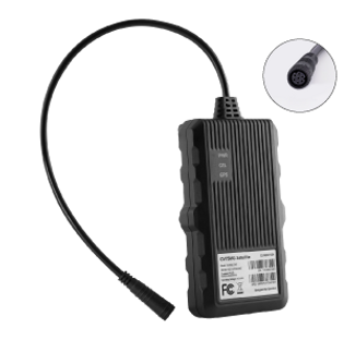
Queclink GV75MG SAT — LTE Cat M1 and NTN Satellite Waterproof Tracker for Global Asset and Vehicle Tracking
The Queclink GV75MG SAT is a next-generation telematics device that combines LTE Cat M1/NB2 cellular connectivity with NTN-IoT satellite network support — enabling uninterrupted tracking coverage even in the most remote locations where cellular networks are unavailable. It can be deployed across a wide range of transportation scenarios including freight logistics, asset tracking and ocean-going vessel positioning.
The GV75MG SAT features a wide voltage input of 9–90V DC and IP67 waterproof housing, allowing reliable long-term installation in vehicles, trailers and equipment operating in harsh outdoor environments. Its 1,100mAh rechargeable backup battery provides up to 2,630 hours of standby time without external power. BLE 5.2 support enables wireless accessory integration including driver identification key fobs and identification readers.
As an authorised Queclink distributor in the UK, Tracking Hardware UK ships the GV75MG SAT directly from our London warehouse — with trade pricing available for telematics service providers, fleet operators and resellers.
Key Features
LTE Cat M1/NB2 + NTN satellite — dual-mode connectivity combining cellular IoT networks with NTN-IoT satellite bands (B23/B255/B256) for truly global coverage including at sea and in remote areas
IP67 waterproof housing — fully sealed against dust and temporary water immersion for reliable outdoor installation on vehicles, trailers and assets
Wide voltage input (9–90V DC) — compatible with 12V and 24V vehicles, electric vehicles and a wide range of commercial equipment
All-in-one GNSS — GPS, BeiDou, Galileo and GLONASS receiver with AGPS support and under 2m CEP accuracy for precise global positioning
1,100mAh rechargeable backup battery — up to 2,630 hours standby without external power, maintaining tracking continuity during power loss
BLE 5.2 — wireless connection to driver identification key fobs, temperature sensors and other Queclink BLE accessories
Configurable digital I/Os — 1 dedicated ignition input plus 2 configurable I/Os for digital input monitoring or relay output control
RS232 serial port — for accessory integration and device debugging
Driving behaviour monitoring — accelerometer-based harsh braking, acceleration and crash detection for fleet safety programmes
Zero power consumption mode — less than 0.4mA at 12V when ignition is off, preventing vehicle battery drain during long parked periods
Technical Specifications
Cellular
Technology: LTE Cat M1 / NB2 with EGPRS fallback
Cat M1/NB2 bands: B1/B2/B3/B4/B5/B8/B12/B13/B18/B19/B20/B25/B26/B27/B28/B66/B85
Cat M1 data rate: Max 588Kbps DL / 1119Kbps UL
Cat NB2 data rate: Max 127Kbps DL / 158.5Kbps UL
2G fallback: EGPRS 850/900/1800/1900MHz — EDGE 296Kbps, GPRS 107Kbps
Satellite
Technology: NTN-IoT satellite
Satellite bands: B23, B255, B256
Sensitivity: B23/B255/B256 -115/-108.2dBm
Region: Global, North America
GNSS
Receiver: All-in-one (GPS, BeiDou, Galileo, GLONASS), AGPS supported
Accuracy: <2m CEP (autonomous)
Sensitivity: Cold start -149dBm, Hot start -165dBm, Tracking -159dBm
TTFF: Cold start 26 seconds average, Hot start 1 second average
Hardware
Dimensions: 112(L) × 65(W) × 20(H)mm
Weight: 160g
Operating voltage: 9–90V DC
Backup battery: Li-Polymer 1,100mAh rechargeable
Standby time: Up to 2,630 hours (without reporting)
Operating temperature: -20°C to +70°C (-30°C to +80°C storage)
Waterproofing: IP67
Bluetooth: BLE 5.2
Zero power mode: <0.4mA at 12V when ignition off
Digital input: 1 × positive trigger for ignition detection
Configurable I/O: 2 × configurable digital input or open-drain output (150mA max)
Serial port: 1 × RS232
Antennas: Internal cellular, GNSS and BLE
LED indicators: CEL, GNSS, PWR
Typical Use Cases
Ocean-going vessel and maritime tracking — NTN satellite connectivity enables ship position reporting beyond coastal cellular network coverage, providing global vessel visibility
Remote freight logistics — combined cellular and satellite ensures uninterrupted tracking through cellular dead zones on long-haul routes across sparsely covered regions
International asset tracking — global satellite coverage means assets are never lost when crossing borders or transiting countries with limited cellular infrastructure
Oil, gas and energy sector — tracking of vehicles and equipment on remote oil fields, pipelines and energy infrastructure where cellular networks are absent
Mining and heavy industry — continuous location reporting for mine site vehicles and equipment operating in remote areas beyond cellular coverage
Construction fleet management — driving behaviour monitoring, geo-fencing and tow alarms protect high-value plant on remote construction sites
Agricultural and rural fleet — wide voltage input and IP67 housing suit farm machinery and rural fleet vehicles in locations with poor cellular signal
Emergency services and government — reliable dual-mode connectivity ensures tracking continuity for emergency response vehicles operating in all environments
Stolen vehicle recovery — jamming detection, tow alarm and satellite fallback maintain tracking even when a cellular jammer is used during vehicle theft
Expedition and specialist vehicle tracking — adventure, scientific and military vehicles operating in extreme or remote environments benefit from always-on satellite coverage
Frequently Asked Questions
What satellite network does the GV75MG SAT use?
The GV75MG SAT uses NTN-IoT (Non-Terrestrial Network IoT) satellite connectivity on bands B23, B255 and B256. This is a standards-based Low Earth Orbit satellite system that provides global coverage including at sea and in remote areas where terrestrial cellular networks are unavailable.
Does the GV75MG SAT use cellular or satellite by default?
The GV75MG SAT primarily uses LTE Cat M1/NB2 cellular when available, automatically switching to NTN satellite when cellular coverage is lost. This approach keeps data costs low in coverage areas while ensuring continuity in remote locations — combining the best of both network types.
How long does the backup battery last on the GV75MG SAT?
The 1,100mAh rechargeable Li-Polymer backup battery provides up to 2,630 hours (approximately 109 days) of standby time without external power. At a 5-minute reporting interval this reduces to around 39 hours, and at 10-minute intervals approximately 126 hours. The device also features a zero power consumption mode drawing less than 0.4mA at 12V when the ignition is off.
Can the GV75MG SAT be used to track ships?
Yes, the GV75MG SAT is specifically designed for scenarios including ocean-going vessel positioning. Once a ship moves beyond coastal cellular coverage, the device automatically switches to NTN satellite connectivity to maintain continuous position reporting. It is suitable for commercial shipping, fishing vessels and other maritime applications.
Is the GV75MG SAT waterproof?
Yes, the GV75MG SAT has an IP67 waterproof rating — fully protected against dust and temporary immersion in up to 1 metre of water for 30 minutes. The 9–90V wide voltage input and rugged housing also make it suitable for outdoor installation on vehicles and equipment in harsh environments.
Is the GV75MG SAT locked to a specific platform or SIM card?
Confirm that your platform supports this exact model and its required protocol and features. Where a cellular SIM is used, the SIM plan, supported bands, operator coverage and device configuration must match the deployment.
ENGV75MG-SAT-Datasheet.pdf
Download PDF • 880KB